EO4EU Tutorial IGARSS 2024#
Prerequisites#
Note
Before starting this tutorial, participants should have:
Basic knowledge of Python.
Basic knowledge of geospatial data formats (raster and vector files).
Basic knowledge of Earth Observation concepts like Copernicus offer and Very High Resolution images.
Prior exposure to AI concepts and tools is recommended.
Participants in this tutorial should have their laptops with Python3 installed/access to Pangeo-eosc JupyterHub and internet connection.
EO4EU Objectives#
AI-augmented ecosystem for Earth Observation data accessibility with Extended reality User Interfaces for Service and data exploitation, or EO4EU, is a European Commission funded innovation project which aims at creating an advanced platform for searching, discovering, processing and analyzing EO data. The platform leverages machine learning to support handling of the characteristically-large volume of EO data as well as a combination of cloud computing infrastructure and pre-exascale high-performance computing to manage processing workloads.
The EO4EU Platform allows for searching, discovering processing and analyzing EO data and is based on a series of innovative technologies which allow to:
Access EO data from different sources (e.g., Copernicus, Galileo, ECMWF).
Support a sophisticated representation of data through a semantic-enhanced Knowledge Graph.
Use Machine Learning from marketplace to EO data processing.
Visualize EO data through easy-to-use graphical interfaces and Extended Reality applications.
EO4EU Architecture#
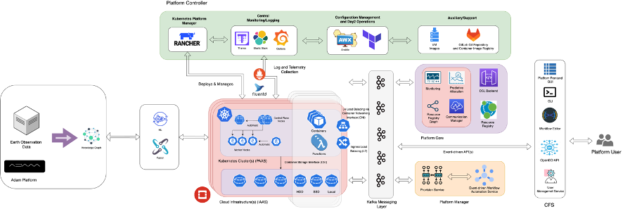
EO4EU Infrastructure#
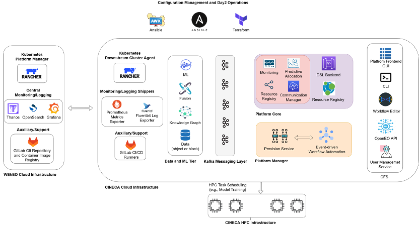
Check out the content pages bundled with this sample book to see more.
EO4EU Use Cases#
EO for Personalized Health Care: to expand mobile allergy and airbrone hazards forecasting.
Food Security: to improve the adaptability of food production using EO4EU for live climate data tracking and analysis.
Soil Erosion: to integrate rainfall datasets through EO4EU to assess soil suspectibility to water erosion.
Civil Protection: to improve disaster and calamity prevention and response using EO datasets.
Ocean Monitoring: to optimize shipping industry travel time across different oceans considering live weather data.
Forest Ecosystem: to improve forest productivity using EO4EU to simulate water, energy and carbon fluxes.
Environmental Pests: to assess and predict the impact of locust plague.
For more information visit EO4EU website
Practical Use Cases